




The United Nations General Assembly has endorsed a new world map Africa spent years campaigning for, and the practical effect lands in places most South Africans see every week. School atlases, textbook orders and the wall map in a Grade 10 geography classroom are all now covered by a UN recommendation.
Member states adopted resolution A/80/L.104, titled “Correct the map”, on Friday 4 September by a recorded vote of 164 in favour to one against, with six abstentions. Togo introduced the text on behalf of the African Group, the 54 African member states at the UN.
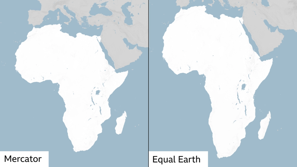
The resolution asks governments, schools, international organisations and technology companies to use equal-area map projections, particularly Equal Earth, wherever the comparative size of continents matters. It bans nothing and binds no one.
The United States cast the only vote against it. The six abstentions were Estonia, Georgia, Lithuania, the Republic of Moldova, Serbia and Ukraine. No African state abstained or voted against.
A 457-year-old map, and what the resolution actually asks for
Flemish cartographer Gerardus Mercator built his projection in 1569 for maritime navigation. Straight lines on it hold a constant compass bearing, which is why generations of sailors used it.
The trade-off is area. Landmasses stretch the further they sit from the equator, which is why Greenland can look comparable in size to Africa when Africa is roughly 14 times larger.
Equal Earth, released in 2018 by cartographers Tom Patterson, Bernhard Jenny and Bojan Šavrič, keeps relative surface areas correct. The UN resolution frames the switch as an act of “cognitive justice and memorial reparation”.
Togo’s Minister for Foreign Affairs, Robert Dussey, told Reuters before the vote that “A fair world begins with a fair map”. He said Togo intends to update its own school geography materials by the end of the year.
South Africa sponsored the text as part of the African Group, in a year that has already included South Africa’s turn chairing SADC. No South African department had published a position on the classroom question by the time of publication.
What the new world map Africa vote changes in South African classrooms
Nothing changes on Monday. The resolution carries no legal force, sets no deadline and names no department.
What it creates is a reference point. A publisher revising a Grade 8 Social Sciences or Grade 10 Geography title now has a General Assembly resolution to cite, and Togo has set a public date others can be measured against.
The cost sits in print runs, provincial procurement cycles and teacher retraining, inside a system already carrying vacant teaching posts across the country. Replacing a wall map is cheap. Replacing a curriculum’s map furniture across nine provinces is not.
How big South Africa really is next to France and the DR Congo
Here is the part the international coverage of Friday’s vote has not run. The switch does not only change how Africa looks. It changes how South Africa looks, and it does so in both directions.
Mercator exaggerates area by a factor of one divided by the square of the cosine of the latitude. Southafriworld applied that standard formula at each country’s approximate mid-latitude.
South Africa sits at about 29 degrees south, producing an exaggeration factor of roughly 1.31. Mainland France sits at about 47 degrees north, producing roughly 2.13. The Democratic Republic of the Congo straddles the equator and is barely distorted at all, at roughly 1.00.
| Comparison | True relative size | As drawn on Mercator | Effect of an equal-area map |
|---|---|---|---|
| South Africa vs mainland France | 2.21 times larger | about 1.36 times larger | South Africa’s lead widens by about 63% |
| DR Congo vs South Africa | 1.92 times larger | about 1.48 times larger | The DR Congo’s lead widens by about 30% |
| Africa vs Greenland | about 14 times larger | roughly comparable | Greenland shrinks sharply |
Two conclusions follow. Measured against Europe, South Africa is drawn far smaller than it is: a true surface area of 1,221,037 square kilometres is about 2.21 times mainland France’s 551,695, but Mercator shows the gap at roughly 1.36 times.
Measured against equatorial Africa, the correction runs the other way. The DR Congo is genuinely about 1.92 times South Africa’s size, while Mercator shows roughly 1.48 times.
South Africa is the ninth-largest country in Africa and the 24th largest in the world. Neither fact is visible on the map most South Africans grew up with, which is the same distortion that flatters comparisons of the sort raised when Morocco overtook South Africa as the continent’s most industrialised economy.
Why the United States voted against it
Yaryna Ferencevych, deputy US representative to the UN Economic and Social Council, told the plenary that resolutions of this type were “barnacles on our work here”. Washington argued the initiative belonged to a wider agenda around reparations and cognitive justice, and pulled the Assembly away from questions of peace and prosperity.
Ukraine, which abstained, said it did not oppose correcting distortions affecting Africa but objected to how some Equal Earth material depicts Ukrainian territory occupied by Russia. Speaking for the European Union, Ireland said the measure covered relative landmass size only and had no bearing on sovereignty or recognised borders.
France moved in the opposite direction. Foreign Minister Jean-Noël Barrot announced hours before the vote that Paris would abandon Mercator, a shift that makes France itself appear smaller against equatorial countries.
Mahmoud Ali Youssouf, chairperson of the African Union Commission, congratulated Togo and President Faure Essozimna Gnassingbé for carrying the initiative on behalf of the African Group. The AU Assembly first endorsed the campaign in February.
What happens next, and what South Africa has not said
Togo plans to meet African Union member states and other supporters over the next six months to press for wider adoption, including among technology companies running digital mapping and location services.
Google Maps and most major online mapping platforms use Web Mercator, adopted in 2005 because it panned and zoomed smoothly across a screen. None has announced a change. That matters for how the continent is presented to the visitors behind South Africa’s tourism arrival numbers.
Several points remain unresolved. South Africa’s Department of Basic Education has published no position on whether CAPS-aligned geography materials will be revised, and no date or budget exists for any such revision. Southafriworld found no statement from any South African department on the resolution at the time of publication, and did not independently verify individual member states’ entries in the UN’s recorded vote list.
The document is A/80/L.104. It was adopted at the 114th plenary meeting of the Assembly’s 80th session on 4 September 2026. Togo’s self-imposed textbook deadline falls at the end of December.